


LIKE OUR COMMUNITY?
Give us a call at
(303) 588-7560
-Emily C, Denver Colorado
April 2013
DID YOU KNOW?
Charles G. Buckingham donated a 5 acre parcel including the falls to the City of Boulder for recreational purposes in 1914.
While the falls usually has a large volume of water flowing over it, with 200-400 cubic feet passing per each second, the 2013 flood the falls may have reached over 12,000 cfs.
On occasion, during especially cold periods, the falls freezes thick enough to be climbed.
Got family in town and don't know what to do?
This is a great place to stop on your way up into the mountains to Nederland, Estes Park, and beyond.
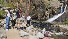
The parking is easy enough, though it can be crowded on busy summer weekends. There is a trail that only takes a few minutes to hike, reaching a pretty spectacular, booming falls.
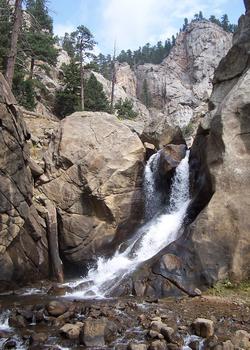
Boulder Falls
Boulder Falls
Lower Boulder Falls Trail and the area around Boulder Falls remain closed. The trail sustained damage in the flood that needs to be repaired and rock scaling above the trail needs to be completed before the trail can re-open. For more information, please call 303-441-3440.
Boulder Falls Area
Boulder Falls is located 11 miles west of Boulder, on the north side of Boulder Canyon Drive (SR 119) between Boulder and Nederland. It consists of five acres of mining claims that were given to the City of Boulder by Charles G. Buckingham, president and co-founder of Buckingham Brothers Bank (now Norwest Bank). Buckingham had held a U.S. Patent since 1881 on the American Mill site that included the Falls. He donated it to the City of Boulder for recreational purposes in 1914, hence "saving this beautiful spot from the encroachment of the great tungsten boom."
For many years, the Boulder Falls (sometimes referred to as the "Yosemite of Boulder Canyon"), was the popular destination for picnic groups. Carryalls brought visitors up for a visit to the Falls, especially after the narrow gauge railroad washed out in the great flood of 1894. When the railroad was rebuilt four years later, stage and tourist travel was diverted and the popularity of Boulder Falls declined.
Today, Boulder Falls receives heavy visitation by tourists heading to the high country from Boulder. Boulder Falls is quite lovely and well worth the brief stop for a look at the cascading water. There is a large parking area just across SR 119 from the Falls; please cross the road with care to access the short trail that leads to a viewing area. Visitors are required to stay on the main path that ends at a viewpoint just below the falls. Here you will have an excellent view of the Falls, forming where North Boulder Creek plunges approximately 70 feet to enter Middle Boulder Creek. For your safety, the area beyond the viewpoint has been closed. The rocks and water past this point are deceptively dangerous, and several people have been killed while scrambling around the falls.
"Picture Rock" is a large gray boulder located just next to the road at Boulder Falls, appropriately named for the large round hole which has framed the faces of countless visitors as they posed for photographs here. The rock eroded naturally to produce the hole and was hauled up from Boulder Creek when the "new" highway was built in the 1940s.
From May 1 until Oct. 31, Boulder Falls is open from dawn to dusk. No overnight camping is permitted, and there are no public facilities at Boulder Falls. All rules and regulations are strictly enforced, and state law prohibits the possession of alcohol greater than 3.2 percent. Glass is prohibited.
Call (303) 588-7560 today to set up a tour of Upper Boulder Falls, Catastrophe Mine Trail, and Dream Canyon.
PO Box 608 Nederland, Colorado 80466 | email: info@privatenaturepreserve.com | call: (303) 588-7560
Falls Pointe Private Nature Reserve
in Boulder County, Colorado
© 2010 Falls Pointe Private Nature Reserve. All rights reserved.